


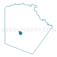
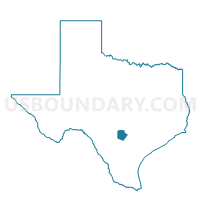
Voting District 1030, Bexar County, Texas
About
Outline

Summary
| Unique Area Identifier | 670692 |
| Name | Voting District 1030 |
| County | Bexar County |
| State | Texas |
| Area (square miles) | 6.72 |
| Land Area (square miles) | 6.70 |
| Water Area (square miles) | 0.02 |
| % of Land Area | 99.71 |
| % of Water Area | 0.29 |
| Latitude of the Internal Point | 29.37891050 |
| Longtitude of the Internal Point | -98.58639780 |
Maps

Graphs
Select a template below for downloading or customizing gragh for Voting District 1030, Bexar County, Texas


Neighbors
Neighoring Voting District (by Name) Neighboring Voting District on the Map
- Voting District 1013, Bexar County, TX
- Voting District 1026, Bexar County, TX
- Voting District 1027, Bexar County, TX
- Voting District 1031, Bexar County, TX
- Voting District 1032, Bexar County, TX
- Voting District 1033, Bexar County, TX
- Voting District 1035, Bexar County, TX
- Voting District 1037, Bexar County, TX
- Voting District 1038, Bexar County, TX
- Voting District 1039, Bexar County, TX
- Voting District 1040, Bexar County, TX
- Voting District 1041, Bexar County, TX
- Voting District 1090, Bexar County, TX
- Voting District 1096, Bexar County, TX
- Voting District 1103, Bexar County, TX
- Voting District 2044, Bexar County, TX
- Voting District 2075, Bexar County, TX
Top 10 Neighboring County Subdivision (by Population) Neighboring County Subdivision on the Map
Top 10 Neighboring Place (by Population) Neighboring Place on the Map
Top 10 Neighboring Unified School District (by Population) Neighboring Unified School District on the Map
- Northside Independent School District, TX (516,430)
- Edgewood Independent School District, TX (57,848)
- South San Antonio Independent School District, TX (44,903)
- Lackland Independent School District, TX (11,714)
Top 10 Neighboring State Legislative District Lower Chamber (by Population) Neighboring State Legislative District Lower Chamber on the Map
Top 10 Neighboring State Legislative District Upper Chamber (by Population) Neighboring State Legislative District Upper Chamber on the Map
Top 10 Neighboring 111th Congressional District (by Population) Neighboring 111th Congressional District on the Map
Top 10 Neighboring Census Tract (by Population) Neighboring Census Tract on the Map
- Census Tract 1614, Bexar County, TX (9,945)
- Census Tract 1607.02, Bexar County, TX (5,314)
- Census Tract 1609.02, Bexar County, TX (4,564)
- Census Tract 1604, Bexar County, TX (4,557)
- Census Tract 1716.01, Bexar County, TX (4,462)
- Census Tract 1613.04, Bexar County, TX (4,290)
- Census Tract 1616, Bexar County, TX (3,958)
- Census Tract 1610, Bexar County, TX (3,898)
- Census Tract 1607.01, Bexar County, TX (3,392)
- Census Tract 1716.02, Bexar County, TX (3,135)
Top 10 Neighboring 5-Digit ZIP Code Tabulation Area (by Population) Neighboring 5-Digit ZIP Code Tabulation Area on the Map
- 78227, TX (46,077)
- 78237, TX (36,929)
- 78211, TX (31,944)
- 78242, TX (31,395)
- 78236, TX (10,392)
- 78226, TX (6,648)
- 78243, TX (235)